A Brief History of Geodesy
Technology advancements in the last 50 years allowed mankind of today to do majority of its work by “the push of a button”. Modern society with a little to no knowledge regarding contemporary mapping techniques has no fright of being lost at any part of the world – navigation device will reliably do its work with no mistake. By merging modern technologies with geodesy, new devices emerged that provided enormous amount and variety in geospatial data that can be obtained at the unthinkable speed. However, navigation functionability and acquisition of geospatial data has not always been the way it is today.
Have you ever asked yourself how would life look like without maps on our smartphones? How would we acquire data and plot a 10 km road section in just 20 days? If we had no modern maps, how would we get from a point A to a point B?
Society that we succeeded has faced big obstacles regarding navigation and mapping out the space that surrounds us. Despite these difficulties, every historic era had its way around them. Ever since humans evolved into conscious beings, their curiosity for the Earth never stopped. Natural phenomena that surrounded them has affected their behaviour and has broadened their knowledge about those phenomena and this knowledge contained geodetic insight of the shape, size and the gravitational field of the Earth.
First traces of geodesy start from the ancient civilizations: Babylonians, Assyrians, Egyptians and Greeks. As the oldest document that is tied with the geodesy is considered to be Haldeian plates, found in the Arabian Desert that are dated from 40th century B.C.
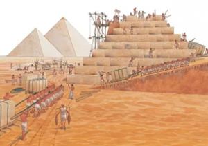
It is believed that geometric sciences were founded in Egypt in priest schools. Surveying dates back to at least 1400 years B.C. as Egyptians used it as a method to form land taxes. They used a plumb line tool for their measures. Engineering geodesy roots originate from Egyptian pyramids as they were being made.
As it can be seen, proportions of the Giza pyramids are outstanding. Although primitive, their methods were proven to be very precise as the spatial extension of the pyramids is almost perfectly aligned with north-south orientation, and they were built almost 5000 years ago. The biggest pyramid of the location is considered to be the tallest building in the world for over 3000 years. It was built out of 6 000 000 tons of stone with such precision and spatial orientation (Image 1).
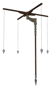
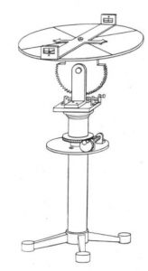
Other civilizations, based on Egyptian methods, developed their own surveying solutions as well as instruments needed for such operations. One of the numerous inventions was “the groma” instrument (Image 2) which was developed in Mesopotamia in 400s B.C. Instrument was used for determining and plotting of the right angle. This patent was mainly used by Greeks and Romans. Inventions of the compass and diopter should also be mentioned (Image 3).
Other scientific disciplines such as mathematics and physics also contributed to the growth in number of geodetic instruments. With the development of optics came the invention of the telescope which was essential for making a prototype of a first theodolite that was made in 1571. and the patent was used up to the middle of 20th century.
For the majority of the 20th century, geodesy found its use for the most part in the military industry (military topographical maps). As in many other areas, World War I and II contributed to a further development of geodetic technologies and maybe the most important one is certainly GPS system that provided 2D positioning.
The main goal for the 20th century geodesy was how to acquire the most data in the shortest time interval possible. The biggest leap in development of geodetic instruments and surveying techniques was achieved by using computer technologies. One of the novelties regarding surveying is laser scanning technology. Task of a laser scanner is to acquire data in a form of georeferenced point cloud. Mobile terrestrial laser scanner is a system that uses laser scanning technology in combination with GNSS and other sensors in order to achieve precise geospatial data from the moving platform.
As we compare founding techniques of acquisition of geospatial data, primitive and in a form of using plumb line tool, with modern methods and instruments, it can easily be said that the tendencies have shifted from achieving high accuracy that required a lot of time to optimization of accuracy and massive amount of geospatial data acquired for the shortest time possible. So, the imperative is to completely shift from post processing to real-time tracking and data acquisition.